

I’ve been gearing up for the Boise Trails Challenge this last week, which means my mileage has been down-shifting—so that my legs can be fresh and my energy can be high when I start next Thursday. My last truly long run, a twenty-one-miler, was a few weeks ago now.
What does twenty-one miles look like?
Well, this is what *I* looked like at the finish, where Patrick picked me up. Or, rather, what I looked like at 20.95 miles. Once I greeted him, I did jog that 0.05 more to get over the twenty-one mark!
The plan for that long run was “in the twenty mile range,” and fell on June 2nd, which was a Sunday, so I opted to run it after church. I made the plans knowing that I’d be in a little more full sun than an early run, and that I’d want to be ready to go straight from church—for efficiency’s sake—rather than going home, getting ready, and heading back out.
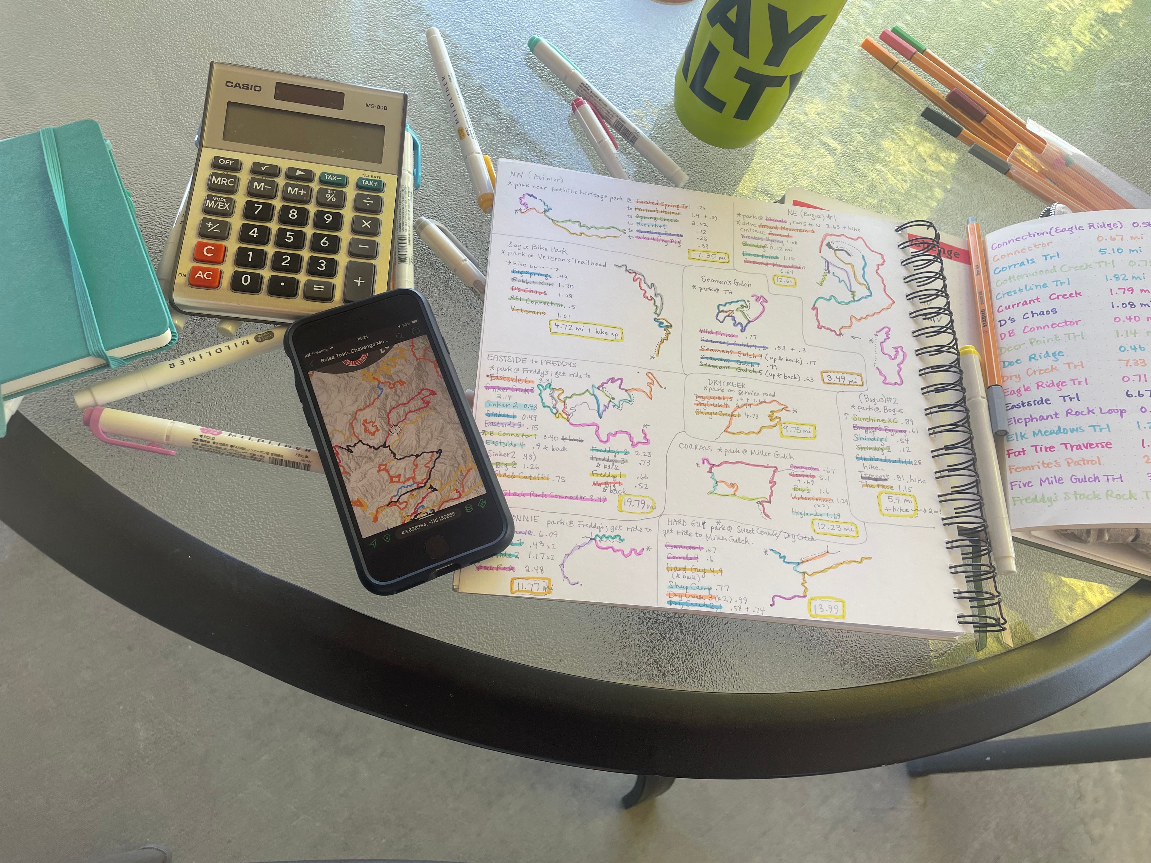
On Saturday, I route-planned. For me, this is an art as opposed to an exact science. It does involve maps and calculators, but it also involves a bit of estimating mileage for segments that aren’t explicitly marked on the map. The priority for me that day was in running a point to point—a route in which I was dropped off in one location, then picked up at the end in another. For a long run particularly, I find it more motivating to have a destination in mind, instead of just needing to find a way back to my vehicle. I also find it fun and interesting to stitch a route together—in essence creating a “new-to-me trail” with trails I’ve already run. Because this run did fall on a weekend, Patrick had more freedom to both drop me off and pick me up, so I wanted to maximize his flexibility as my driver when I could!
I made my starting point the Jim Hall Learning Center, an easy to access trailhead that wasn’t a long drive from church, so it would be convenient for Patrick to drop me off. I then picked a gradual and steady uphill trail with water access to begin with. I’d be able to get my hat and sleeves wet to keep cool as it would be around one in the afternoon when I started. I also packed my filter so that I could use the creek to refill one of my small flasks when I reached the top. The last thing you want to run out of on a long afternoon run is water. The rest of the run was a mix of shorter climbs and long descents, which is a lovely way to mix up a long run, in my opinion, and included parts of some of my favorite Ridge to River’s Trails, complete with magnificent views, as usual.


For locals, here’s the route. I scribed it into my journal, then took a picture for Patrick so that he’d know my intentions in case anything went wrong.
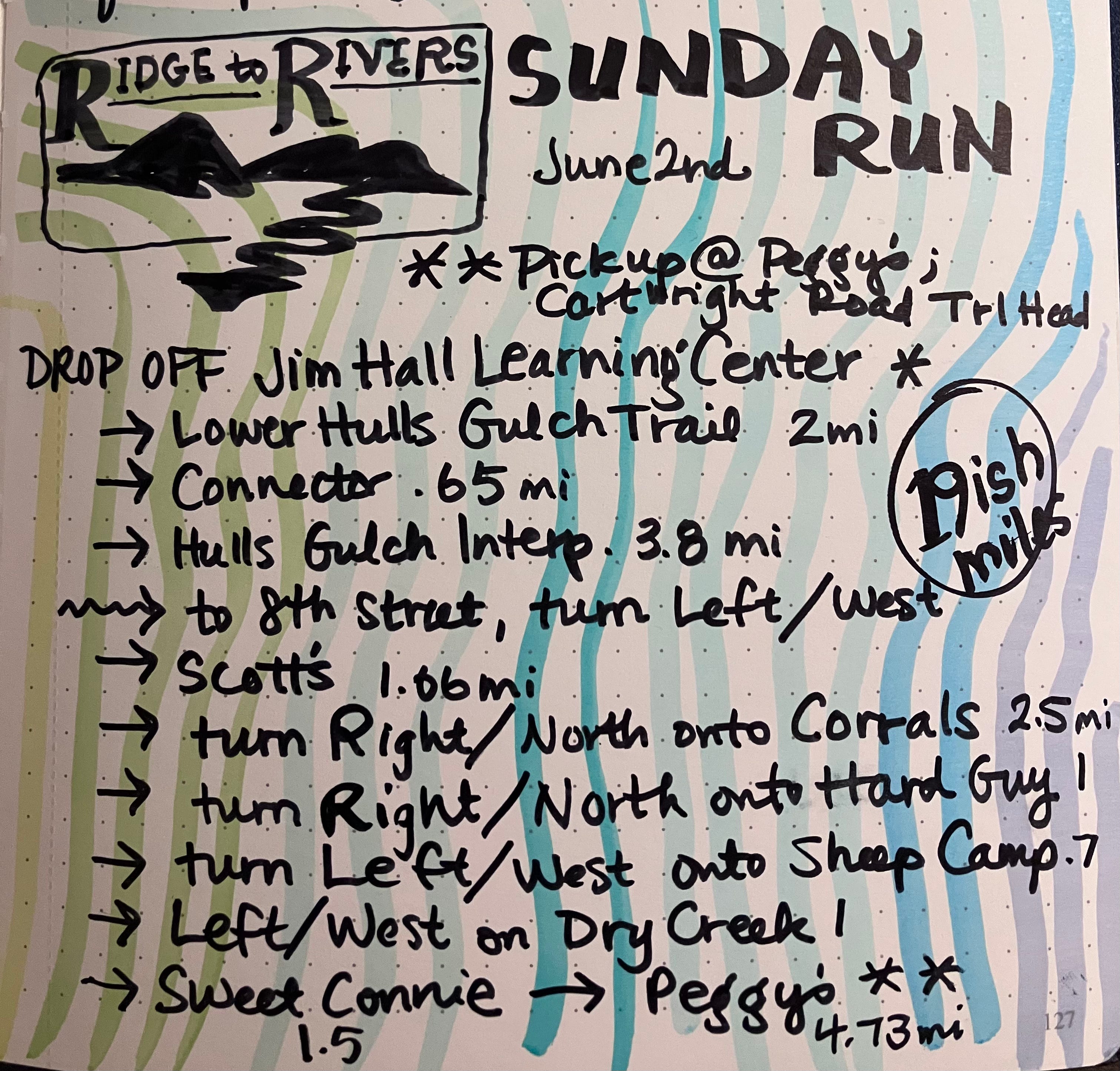
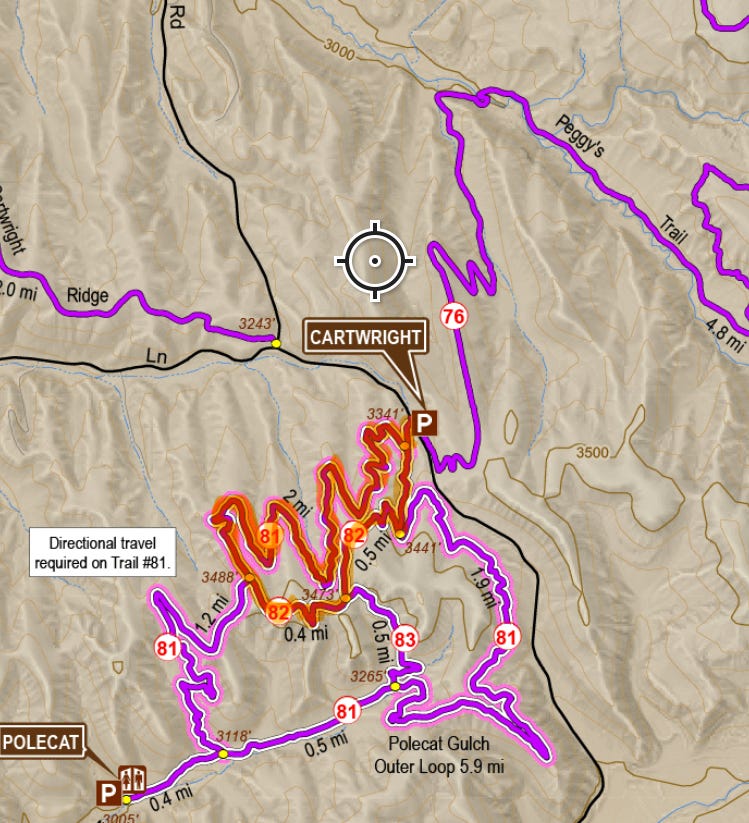
When I made it to the end of Peggy’s, my watch was only reading 17.7 miles as opposed to “19-ish,” but I knew I was willing to go over twenty. So I added the approximately three mile Doe Ridge to Polecat Loop onto the end before I called Patrick, pushing the route to nearly twenty one. I had discussed this possibility with Patrick ahead of time, which was one reason I chose Cartwright Trailhead as my pick-up point.
It’s a lovely strategy. I could simply be done at the end of Peggy’s Trail, OR I could use part of Polecat Gulch Loop to add mileage. Either way, Patrick still picked me up in the same spot.
To keep in mind when route planning:
As already mentioned, water sources. (For cooling and/or drinking, if you carry a filter.)
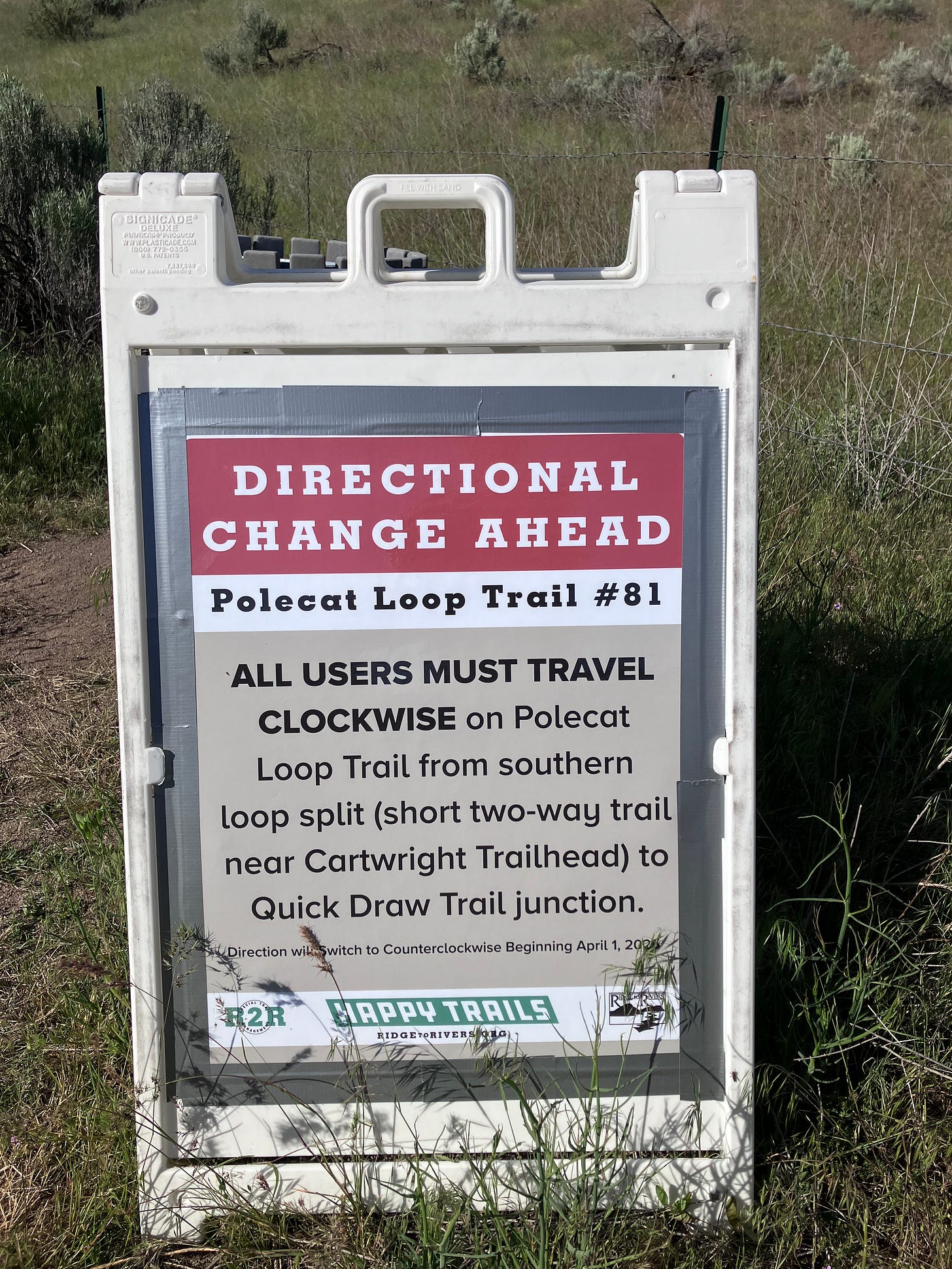
Directional trails. Polecat, which I added at the end of this route, is a one-way trail; currently it’s to be run clockwise.
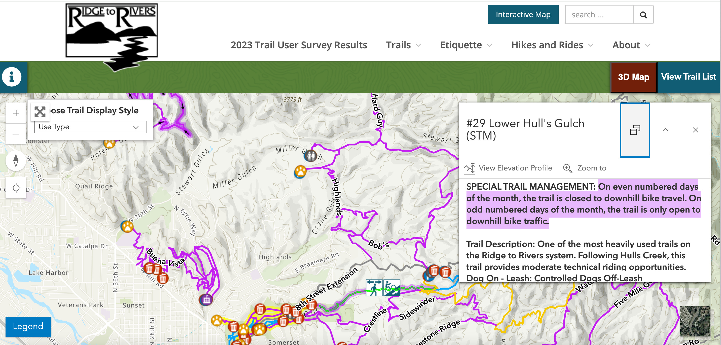
Special trail management. The trail I began with, Lower Hulls Gulch, is only open to foot traffic on even numbered days. Sunday, being the 2nd, was a perfect day to utilize this gradual, creekside climb. You can determine what the special trail management rules are by using the Ridge to Rivers interactive map. Look for the trails highlighted in purple.

Timings of sunrise & sunset. I carried my headlamp in case something awful happened. But Patrick was able to pick me up within the range of when we’d planned, around six in the evening, so I actually had hours of daylight left here in Boise at this time of year. (But you never know!)

Now that I know the Ridge to Rivers system reasonably well, I find route planning fun. When I first arrived here, however, I would have found this kind of point-to-point somewhat stressful to plan. When you’re not exactly sure what terrain you’ll be running on, what kind of wildlife you may encounter, or what the creek crossings will look like, it can be tricky to piece together.
I’ve grown used to the full exposure of the Boise trails and use various forms of sun protection now on every run. I’ve come to expect occasional creek crossings in which I must get my shoes wet. I’ve accepted that I will always be running on hills. I have learned to look forward to liaisons with livestock.
But each one of these things stressed me out when they were new and unexpected experiences.
A common Ridge to Rivers encounter is indeed with livestock. This past weekend, Patrick went with me on a six miler at Hawkins Range Reserve. A few miles in, he asks, “What’s with all the gates?”
I hadn’t given the gate opening and closing a second thought. They’re everywhere.
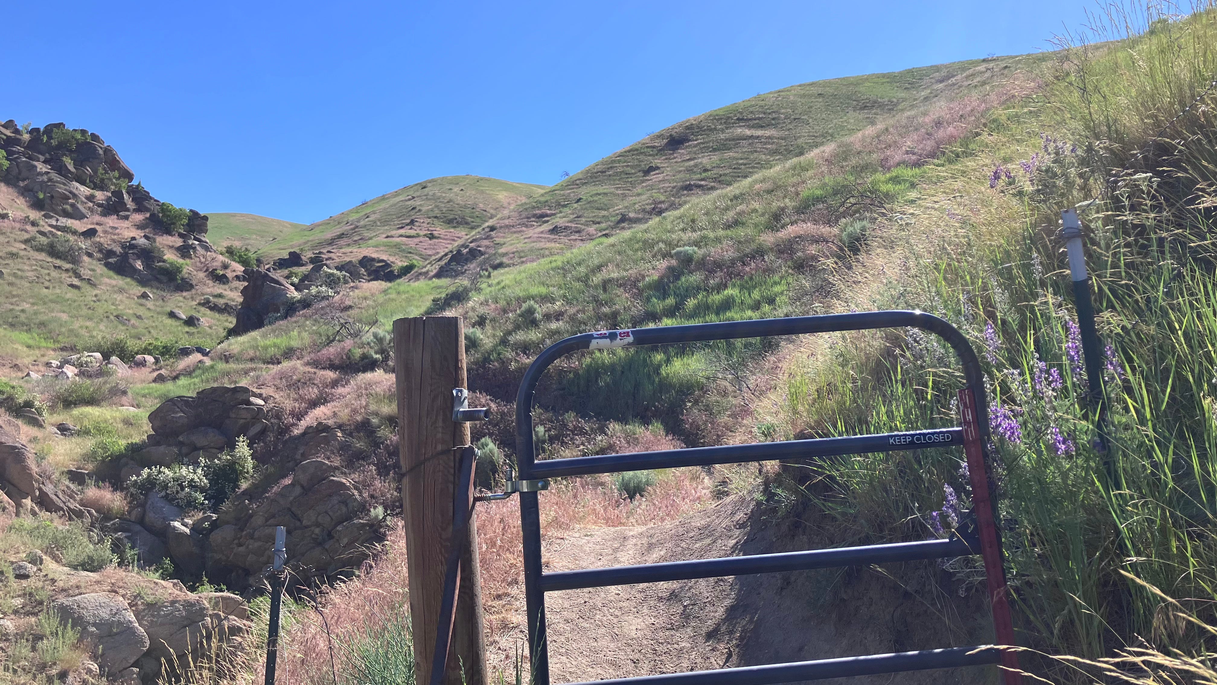
But his question reminded me of when they were new occurrences for me too, and brought to mind my first trail excursion on which I actually shared the trail with the livestock that roam within these gates.
I was running solo, and honestly scared to death to pass so closely to the cows flanking my single track route up Sweet Connie. I remember stopping . . . assessing . . . thinking through my options . . . Go around them? Stay on path? Turn around?
Then I remembered that I was not the only one out there, and that these cows were likely accustomed to runners like me passing. In fact, that morning, I’d already been passed by a few groups of mountain bikers. Certainly, if the cows were cool with bikers whizzing past, then surely they wouldn’t blink an eye at me, right?
True. They didn’t seem bothered at all as I respectfully made my way among them.
But I was nervous as heck!
It took several runs with cows before the stress response in my body calmed. That’s how exposure therapy works, right?
I tackled night running the same way back in Texas. Practice and exposure can calm a myriad of fears.
The same holds true for the practice of route-planning. It's not easy to start doing, but the more you do it the easier it gets. Now I think it’s fun.
In fact, it’s a big part of the fun I’ve been having as I anticipate the Boise Trails Challenge.
So much route-planning!
I’ve honestly spent HOURS mapping out my runs for this event.
But my year here in Boise exploring the Ridge to Rivers system has demystified big parts of the Boise Trail Challenge puzzle. On the days I’ve sat down to route-plan for BTC, I’ve heavily relied on the experiences and data that I’ve collected over the last twelve months of runs.
Maps are helpful, but they only paint a part of the picture.
Which is why I sympathized with some of the BTC participants that showed up at the Q&A last night at Shu’s Idaho Running Company. The event’s facilitator, Colton, did an awesome overview of his Boise Trail Challenge process, and fielded questions like a pro.
Most of those questions centered around route-making. It makes sense. The Boise Trails Challenge requires 177.25 miles of trail, but many of those are out-and-back, or not directly connected to another required trail, or are tucked pretty far back into a system of trail that you can’t get to quickly or easily. The veterans at the Q&A estimated that to most efficiently cover the 177.25 miles, on-foot participants would *actually* traverse around 220 miles. And although both Colton and the veterans had ideas and advice to give, route planning remains a big obstacle for those who didn’t sign up because they enjoy pouring over maps for hours before they hit the trails.
And that’s okay. I hope that the BTC participants that don’t want to do a lot of route planning don’t. Just getting out there and tagging some trails is a worthwhile endeavor, and the spirit of the challenge seems to be more about discovering and experiencing the trails, than about simply covering each one in sequence. Every route-maker has their own individualized process anyway. Maybe—like the trails themselves—it’s meant to unfold as a part of the journey.
Perhaps this will be the year that some just fall in love with the trails, learning through experience how route planning works best for them.
And maybe for others this will be the year they make friends with livestock.
