


I fell in love with the Ridge to Rivers trail system from afar.
Before we moved to Boise, I checked out their website and on-line interactive map well before we bought our house. And you’d better believe that the number of miles from door to trail was something I researched for every home that we toured in that pre-move season. (In the end, we don’t live as close as I would’ve liked to the side of town with all of the trail access, but we do live very close to the City Connector, which drops me on the right side of town in about fifteen minutes by car.)
It was while I was still in Austin, drooling over the Ridge to Rivers maps—and its over 200 miles of trail system—that I decided I should make it my personal goal to cover all of those miles during my first year in Boise. I imagined buying one of the paper Ridge to Rivers maps, hanging it up somewhere, and hand-marking each route when I got home each day, until there was no trail left unmarked.
Despite being a pen & paper kind of girl, I never did buy a paper map.
A new trail friend that I met through Boise’s chapter of Trail Sisters got me set up with Avenza Maps just a few trail runs into my goal. Avenza makes trail navigation simple, and works via GPS, so it doesn’t matter if I have a signal. It tells me where I am and which direction I’m pointing, and what my coordinates and altitude are. It eliminates the need to plan a detailed route *before* every excursion, and allows me the confidence and flexibility to change my plan at any point in my run.
I can also tell it to track and save any trail excursion I’m on. My Garmin running watch will do that as well, but the difference is that all of my routes are saved onto the same map in Avenza, whereas with Garmin I have to open each run individually to see my route. It didn’t take me long to realize that I could use Avenza to keep track of every trail I’d covered, and easily see which ones I hadn’t, all in one place, right on my phone.
My goal-oriented trail running self was ecstatic. I started trekking and tagging trails right away. What a fun year this was going to be!
And then I discovered that many Boiseans collectively pursue this very goal every year…except that they complete the whole system in just thirty days. What!?
It’s called the Boise Trails Challenge, and it takes place every mid-June to mid-July. It was originally a mountain biking thing, but then it morphed into a runner and hiker thing too.
Fortunately for my family, although we moved to Boise on June 17th, just a few days after the 2023 challenge commenced, I didn’t find out about it for a few days. For those completing the challenge on foot, thirty days requires quite a big time commitment—not only in covering all of those trails, but in planning logistics as well. Not every trail is easy to access, and there’s no super straightforward way to cover them all sequentially—lots of “uncounted” miles are logged on out-and-backs, and sometimes the most efficient way to cover a trail doesn’t get you back to your car—so it’s best to have a plan, and even better to have a support system.
Let’s just say that getting to know the city and managing the unpacking of our home was likely where I most needed to be spending my time—no matter how appealing the BTC was to this brand new Boisean.
So I put the Boise Trails Challenge on my 2024 list of events, and went about with my original goal of checking off all of the Ridge to Rivers trails over the next year—but now with more intention. What began as a fun way to personally explore *all* of the trails in my new stomping grounds became a reconnaissance mission.
I’m not just looking to make it on every inch of trail that Boise offers, but I’m taking notes on how to get places, and which routes make most efficient use of my two feet. Some trails in the BTC are required to be covered uphill, but others count no matter which way you run them, so I’m noticing which direction I prefer as well. Among other factors to consider: exposure, temperature, elevation, and time of day.
So when I head out for a trail adventure, I’m not just keen on getting the entire Ridge to Rivers system filled in, I’m specifically prioritizing the Boise Trail Challenge map. The required trails are in green.
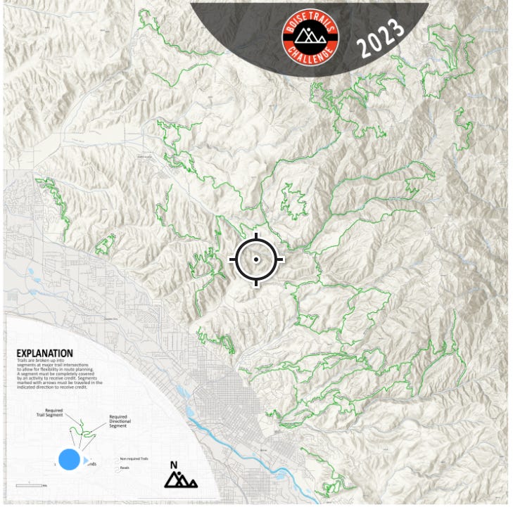
This part is key: although the point of the BTC is to expose trail users to all of the trails that Boise offers, because it’s a biking event first, it does not include trails that are for foot traffic only.
So in my pursuit to cover all of the green trails, I’d neglected a few of the foot traffic only gems out there. It was my interaction with one of Boise’s cool trail running groups that helped to fill in this gap in my explorations.
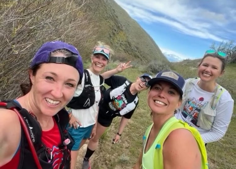
Last Thursday evening I hopped on Instagram to check out what Trail Fridays was planning for their meetup the next morning. I don’t always join, but if they had a five or six mile route I was interested in, I was game—even if it didn’t align with one of my yet-untagged green segments. Sometimes I do prioritize social runs over my personal trail goals.
When I checked out the proposed route, I knew I hadn’t covered it yet, but I also didn’t realize that I was missing part of my BTC map in that area. I zoomed in for a closer look, and realized that this pedestrian-only path had escaped my notice during earlier runs—because it wasn’t green. The path, Hulls Gulch Interpretive Trail, sounded lovely, so I decided to join up with the Trail Fridays group in the morning. I still have plenty of time to do BTC reconnaissance, and my real goal after all is to cover all of the trails, not just the green ones.
When I headed out on Friday morning, I was prepared for a longer drive than usual—due to the trailhead being somewhat high up—and a social run.
The drive was indeed as expected.
But the social part, not so much.
I’d gotten the correct route, but not the correct group meeting place. My bad.
When I realized my mistake, I decided to just do the run on my own. I’d already driven to the higher up trailhead, so why drive back down? There will be more Trail Friday group runs. My only regret was that I didn’t have my headphones with me.
I’m so glad I didn’t, though.


This pedestrian-only path was a beauty. And the path was almost always within the sound of the creek, its flow a constant companion on this spring foothills run. So life-giving and peaceful. Listen past the crunching of my feet to the water sounds:
And at the top, a waterfall! Check out the super picturesque bridge in the background too.
I truly enjoyed covering these particular trail miles solo. The views and water-sounds and cool spring air were all the company required.
And although I was by myself, my singular trek also ended up pretty social too. Some of the other trail users I just exchanged simple greetings with. At one point when I’d stopped to stow my windbreaker in my pack, I crossed paths with a hiking couple from Alaska and enjoyed a conversation via one of those on-trail kinships that happen from time to time. Later, a young woman hiking with her doggo inquired after my bloody knee (I scraped it during a random fall a few minutes earlier), wanting to make sure I was alright. And eventually, I actually ran into and stopped to swap stories with a small group of runners from Trail Fridays, bringing my solo but social run full circle.
Honestly it was the perfect blend of solo and social. Most of my excursion flowing on my own two feet with only the sights and sounds around me as company—yet punctuated with human reminders that I’m part of a group much bigger than me too.
It’s not just the Ridge to Rivers trail system that I’m fond of. I’m rather fond of the many like-minded trail users that love her too.
It’s a beautiful community to keep company with—intentionally or not.